Romania Use Case: AI and UAV Technologies Support Biodiversity Monitoring in Diverse Landscapes
Using UAVs, AI, and advanced Earth Observation technologies, the Romanian BioClima pilot is monitoring biodiversity and habitat change across the Dobrogea and Iron Gate regions
 Ionuț Șandric (University of Bucharest)
•
June 24, 2026
Ionuț Șandric (University of Bucharest)
•
June 24, 2026
The Romanian BioClima use case is exploring how artificial intelligence and advanced drone technologies can improve biodiversity monitoring and habitat assessment across some of the country's most valuable natural areas.
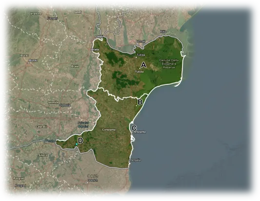
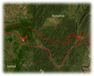
The work focuses on two contrasting regions: Dobrogea, one of Romania's most important steppe biodiversity hotspots near the Black Sea, and the Iron Gate National Park, a Natura 2000 protected area located along the Danube Gorge. Both regions are rich in biodiversity but face increasing pressures from climate change, land-use change, habitat fragmentation, and vegetation degradation.
Combining UAVs, AI and Field Observations
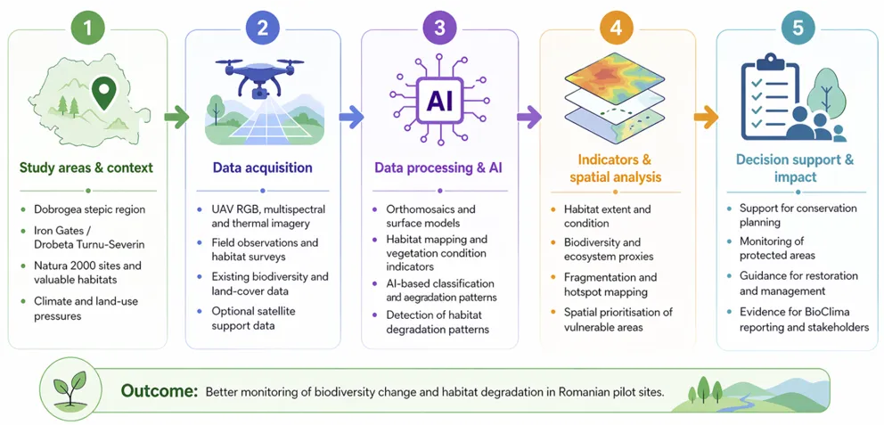
The Romanian team is developing an AI-driven workflow that combines data from multiple UAV sensors, including RGB cameras, multispectral imagery, thermal sensors, and LiDAR technology. The objective is to improve the monitoring of biodiversity, vegetation structure, and habitat condition at a very high spatial resolution.
The workflow integrates field observations, drone surveys, data processing, artificial intelligence, and spatial analysis to generate indicators relevant for biodiversity and climate monitoring. These outputs will contribute to the assessment of Essential Biodiversity Variables (EBVs) and Essential Climate Variables (ECVs).
Monitoring Habitats from the Air
Throughout 2025, UAV campaigns were carried out across both pilot regions. The surveys produced RGB, multispectral, thermal, and LiDAR datasets that are being used to map habitats, analyse vegetation structure, identify land-surface temperature patterns, and detect signs of habitat degradation.
Researchers are also preparing AI training datasets based on detailed field mapping of habitat and land-cover classes such as forests, shrubs, grasslands, scattered trees, and other landscape features. These reference datasets will help train and validate AI models for habitat classification and biodiversity assessment.
Biodiversity Monitoring in the Iron Gate Region
One of the interesting activities is taking place at the Eșelnița Research Station in the Iron Gate region, where field observations are being used to support UAV-based monitoring. Researchers are studying habitat characteristics and microhabitats used by turtles and comparing field observations with drone-derived thermal, multispectral, and LiDAR data. This work helps evaluate how vegetation structure, surface temperature, and habitat configuration influence species distribution and habitat suitability.
Expected Results
The Romanian case studies have already generated a comprehensive Earth Observation dataset covering both coastal and inland ecosystems. The expected outcomes include validated indicators related to ecosystem extent, habitat condition, vegetation structure, biodiversity patterns, land-surface temperature, and local microclimatic conditions. These results will support the development of scalable monitoring approaches that can help improve biodiversity conservation and climate adaptation efforts in Romania and beyond.
Through the combination of UAV technologies, artificial intelligence, and field observations, the Romanian BioClima team is demonstrating how innovative monitoring approaches can provide new insights into the relationship between biodiversity, habitats, and climate change.